A guide to churches and graveyards in Surrey for family historians
|
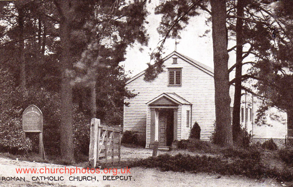
St Oswald’s was a Roman Catholic chapel which was dismantled around 1998. This is a link to the announcement in the London Gazette January 1935 that the Secretary for War had applied for the church to be registered for the solemnisation of marriages. However we do have a note under Frimley: A wooden chapel, for the use of the Catholic soldiers, was commenced here, Oct. 1906. The building, which will probably be finished by Christmas, is for about 300. Architect,B.Williamson,Esq. The mission, which was commenced in June 1900, is under the care of the Rev. Geo. Boniface. Historical notes on English Catholic missions, Kelly, Bernard W. (Rev), 1907: WSFHS has no records to St Oswald’s Church. We do hold some monumental inscriptions for the Garrison church -- St Barbara’s -- which was a short way along the road Surrey History Centre holds marriages registers for 1935 to 1985 Deepcut is in the West Surrey unitary authority area of Surrey (from April 2027)
Unless otherwise stated, the dates for the creation of parishes are taken from Youngs, Frederick A., Guide to the Administrative Units of England; Royal Historical Society: London, 1979 volume 1 Southern England.
The West Surrey Index will show you all the churches and cemeteries we know of in the West Surrey area of Surrey From April 2027 Surrey County Council and the existing district councils will be replaced by two unitary authorities: East Surrey and West Surrey.. If we have missed any churches, or you are looking for a church or graveyard that might no longer exist do please let us know using the "contact us" link at the bottom of this page. If you came to this page from our main index to churchyards. If you came from the West Surrey page use the button at the top of this page to close the page and go back to the main browse page. |
LinksLinks open a new browser page. Close them to see this page again.
Wikipedia A 1946 view from the air Contact us |